Your Cart is Empty


Item Number: 010-02088-0H
Precise Garmin navigation meets global communication in the GPSMAP 66i premium GPS handheld with inReach satellite technology.
The sturdy, button-operated GPSMAP 66i features a large 3” color display you can see even in bright sunlight. If you’re out in the field for long stretches of time, you can turn on Expedition mode and get up to 200 hours of battery life while using inReach technology. In the default tracking mode, you get up to 35 hours of battery life, and your device will save your location every 10 minutes.
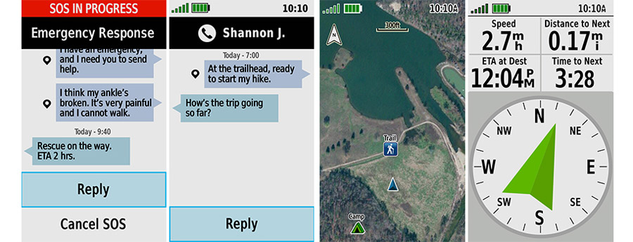
Staying in touch is vital, even on less challenging trips. Using inReach technology (subscription required), this handheld lets you trigger an SOS to the GEOS 24/7 emergency response team for interactive support in an emergency. It also enables two-way messaging and location sharing via the 100% global Iridium satellite network, so you can stay in contact with loved ones, teammates, headquarters and more.
GPSMAP 66i is fitted with the best in Garmin navigation. Direct-to-device downloads of BirdsEye Satellite Imagery provide high-resolution photo-realistic views of your route, trailheads, clearings and more — without an annual subscription. Support for multi-GNSS combined with altimeter, barometer and compass navigation sensors let you track and navigate in challenging environments.
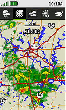
Know what conditions to expect en route using the optional inReach weather forecast service to get detailed updates on GPSMAP 66i or a compatible device paired with the Garmin Explore app. You can request weather forecasts for your current location or other waypoints or destinations on your itinerary. Cellular connectivity lets you access Active Weather for up-to-date forecasts — including predictive maps for temperature, wind, precipitation and clouds — right on the handheld when connected to Garmin Connect.
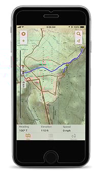
The free Garmin Explore mobile app lets you plan, review and sync data, including waypoints, routes, activities and collections. Review completed activities while still in the field, even when you’re off the grid. The app also lets you sync your GPSMAP 66i with your compatible mobile device so you can access unlimited maps, aerial imagery and U.S. NOAA charts. You can even use all of the inReach features on your paired mobile device. For easier messaging, you can access your phone’s contact list from the Garmin Explore app to connect with fewer keystrokes. Plan for future trips, and review previous activities from the Garmin Explore website.
Some jurisdictions regulate or prohibit the use of satellite communications devices. It is the responsibility of the user to know and follow all applicable laws in the jurisdictions where the device is intended to be used.